One of the best known archaeological sites in Newfoundland and Labrador is the Maritime Archaic cemetery at Port au Choix. The site was found in 1967 during the excavation of a building. Dr. James Tuck of Memorial University investigated this discovery in the fall of 1967 and returned to the site for the next two summers. It would become one of the most instructive Maritime Archaic sites yet excavated. The site revealed approximately 100 graves covered with red ochre. The excellent preservation allowed for the recovery of an incredible array of organic artifacts including daggers of ivory, antler, or bone, bone toggling harpoons, barbed bone points, bone awls, and fine needles, small chisels and knives made from beaver incisors as well as shell-beaded clothing. They also recovered numerous chipped stone projectile points, slate spears, gouges, axes, adzes and lance artifacts. The artifacts and the organization of the burials indicated an elaborate and sophisticated technology used by these people and suggested a complex social organization. The information gained from the excavation would form the basis of the definition of the Maritime Archaic Tradition. The site, along with the extensive Pre-Inuit occupation of Phillip’s Garden, would become a National Historic site of Canada.
The year before the 1967 discovery in Port au Choix, brothers Frank and Stanley Curtis dug a large hole for an outhouse on their property in Back Harbour, Twillingate. They found a slate spear point, followed by thirty-four more stone artifacts. Provincial authorities were informed and they contacted Dr. William Taylor, Director of the former National Museum of Man in Ottawa. The museum sent archaeologist Donald MacLeod to assess the new find and carry out archaeological work if needed. Over the next four summers, MacLeod found, tested and excavated nine new archaeological sites including the Maritime Archaic cemetery in Back Harbour. Unfortunately, MacLeod never wrote a report on any of the work, all we have are rough field notes. As a result, the sites are relatively unknown, despite their importance, particularly the cemetery.

Pre-Inuit and Maritime Archaic sites (courtesy Donald MacLeod) (Temple 2007). The red dot is Curtis site.
The information in this post is based on MacLeod’s cursory field notes and two relatively recent reports that were written based on those notes. In 1993 Paul A. Thibaudeau wrote an essay entitled The Curtis Site: Its Place Within the Maritime Archaic as part of an Honours degree for Carleton University. In 2007 Blair Temple under contract to the Provincial Archaeology Office wrote The 1966-69 Archaeological Excavations At Back Harbour, North Twillingate Island, Newfoundland which provided a synopsis of all of MacLeod’s work in the Twillingate area.
MacLeod excavated the cemetery from 1966 to 1968. During those three field seasons, no human remains were recovered but around 300 tools were found. The analysis was performed on the soil and ochre areas that were believed to be burials. That analysis revealed abnormally high amounts of phosphorus and calcium, compared to control samples which Macleod interpreted to mean the former presence of bone. Similar ‘boneless’ cemeteries had been found along the coast of northeastern North American since the late 19th century and became known as Red Paint Burials and later as the Moorehead Burial Tradition, after the archaeologist who would first describe them. The cemetery at Port au Choix was one of the first Moorehead cemeteries with human remains. The culture of the people who created the burials at Port au Choix would later become known as the Maritime Archaic Tradition. The people of this tradition also created the cemetery at Back Harbour but initially, MacLeod referred to it as either a Red Paint or Moorehead cemetery.

The initial 1966 hole dug by the Curtis brothers was approximately 4×4 feet in size, and 3 to 4 feet deep. MacLeod would expand upon this and open as many as 10 units near the hole dug by the brothers. In 1966 MacLeod spent most of his time in Twillingate excavating the cemetery which he identified as a late Archaic Red Paint burial. He recovered 52 artifacts, several radiocarbon samples and thought the burials may have been the result of cremation.
He noted that burials 1 & 2, excavated in 1966, contained separate layers of ochre at depths between three to five feet. To MacLeod, this suggested that the site was used previously. The uppermost ochre layers were covered by an irregular deposit of angular rocks, while the grave intrusions were nearly six feet deep, with strongly sloping sides. He speculated that this was due in part to the gravel matrix that the graves were dug into.

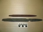
MacLeod’s notes record that many of the tools were covered in red ochre or found in oval deposits of red ochre, usually about 1 to 2 metres below the surface. The longitudinal axis of the tools lay oriented East-West.


location of the profile within the burial is
not known. (Courtesy Don MacLeod) (Temple).
During his two week 1967 field season, he added a further 400 square feet to the excavation and found another 75 artifacts. At this point, he believed the site was significant enough to require a third season.
MacLeod finished the Curtis excavation in 1968 and summarized the three seasons at the site in his notes recording that they recovered more than 300 artifacts from just 15 burials. They had four radiocarbon dates 3720±130 (Gak 834); 3560±140 (Gak 758); 3200±90 (Gak 1254) and 6920±160 (GSC-834). The last date was rejected by MacLeod. The other three dates fit perfectly within the late Archaic, in fact, the date of 3200±90 was and remains the latest date for the Archaic on the Island. The charcoal samples all come from the grave intrusions and were either in association with or directly mixed in with the red ochre deposits in the graves. Thus the charcoal may be related either to the cremation of human remains or to the manufacture of red ochre, or both.
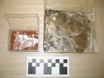
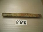
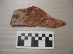
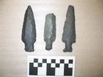
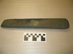
Approximately 300 typical late Archaic artifacts were recovered including various woodworking tools like ground slate gouges, axes, and adzes. As well, chert projectile points, ground slate lances/bayonets (including one with serrated edges) and soapstone plummets were found. There were also some more unusual items such as sheets of mica and an oval piece of copper that was found below the rocks in the horizon of burial 6. MacLeod also recovered numerous natural stones including at least one dumbbell-shaped stone that was encrusted with ochre on the lower, larger lobe. This object may have been used as a pestle for grinding ochre. Some of the other natural stones were little more than rounded pebbles, some were covered in ochre and others were plain white quartzite or quartz stones. Similar stones were recovered at Port au Choix where they were often found near the head of the deceased.
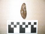
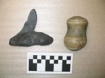
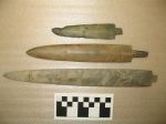
Another unusual artifact was interpreted by MacLeod as a ground Argillite netting needle found in Burial 13 that was caked in ochre. A similar but smaller object was recovered from the Port au Choix cemetery.


The quantity of these artifacts is not evenly distributed among the burials. Burials 4, 6, and 13 have the most variety and greatest number of tools and other items, containing 40, 52, and 76 respectively, or 168 artifacts in all. More than half of all the artifacts were found in these three burials. There are four other burials in close proximity to these central three that have another 86 artifacts. Meaning more than 80% of all the artifacts were clustered with these seven central burials in a 26-foot long x 16-foot wide area. Thibaudeau has suggested these central burials, 4, 6, and 13 were of ‘important’ people with successively less ‘important’ people buried near them (1993:32).

Jim Tuck recorded that there were many similarities between the Curtis and Port au Choix cemeteries as seen in the burial practices which were ‘…nearly identical to those at Port au Choix with the use of red ochre to cover flexed burials (inferred from grave size), the accompaniment of rich grave furnishings, and the grave covering of rocks or small boulders.’ (1976: 102). As well the radiocarbon dates show the two cemeteries were contemporaneous. In fact, the only major differences between the two cemeteries are that there were around 100 burials found at Port au Choix and the latter was fully documented in reports and papers. Despite these differences, Curtis is no less significant.
MacLeod, Donald
1966 Newfoundland 1966. Fieldnotes. CMC Ms. No. 940.
1967 Season Field Notes. CMC Ms. No. 938, Book 1.
1968 Newfoundland 1968 Book II.
Temple, Blair
2007 The 1966-69 Archaeological Excavations at Back Harbour, North Twillingate Island, Newfoundland.
Thibaudeau, Paul
1993 The Curtis Site- Its Place Within the Maritime Archaic
Tuck, James
1976 Ancient People of Port au Choix- The Excavation of an Archaic Indian Cemetery in Newfoundland.

Port au Choix National Historic site received 9,954 visitors during the 2016 operating season. almost 15% more than the previous year. In fact 2016 visitation levels were the highest on record during the 10 year period of 2007 to 2016
Thanks for the information.
By remarkable coincidence I am at the moment finally producing a report entitled “Hathaway Site Catalog Guide” for the Hathaway site in Maine. I excavated at the Hathaway site in 1968 and 1969. It was the first major excavation carried out under my direction in my long archaeological career. There turned out to be four components at Hathaway, the earlier two of which paralleled those found by David Sanger at the Cow Point site in New Burnswick during that same era. Hathaway and Cow Point were also clearly related to Port au Choix and Curtis in Newfoundland. With the completion of the Hathaway report I will have digitized all records and reported all relevant metadata on the (50+) sites on which I carried out significant excavations over the last half century. All materials from those sites will have been deposited in appropriate trusted repositories for permanent curation. The partial Hathaway assemblage that I still hold will join the rest of that assemblage and a separate on from the (Maine) Salt Pond Project at the University of Maine in Orono. I am sure that the faculty and staff at the University of Maine would welcome interest in these materials by visiting scholars. It is perhaps ironic that the excavations and assemblages resulting from my earliest efforts should be the last to be digitized and deposited. But these, of course, are the farthest removed in time from the electronic tools we later acquired, and digitizing takes a lot of fresh effort in these cases. The records and reports for Hathaway and the Salt Pond Project will be uploaded to the tDar system maintained by Digital Antiquity very soon. With that I will have done my duty and interested researchers will be able to see on line everything (databases, photos, forms, reports, etc.) I have produced from anywhere they happen to be. To see the physical collections, of course, will still require travel to places like the University of Maine, the New York State Museum, and Penn State. Thank you for posting your report on the Curtis site and for reading this long comment. I hope that there will be nenewed interest in this regional phenomenon as a result.
Thanks for the comment, it is great news that you are getting your report written. My post has generated some research interest in the Curtis site which is a good thing.
Hello, I loved reading this article and I am currently preparing a project on the Curtis Site for my North American Archaeology course. I was wondering where you were able to find your sources? I haven’t been able to find them in any article databases. Thank you for your help! I hope to generate more interest in this site among my peers.
Hi, please send an email to shull@gov.nl.ca at the Provincial Archaeology Office, they have some unpublished documents.